IBM PAIRS Geoscope brings geospatial-temporal data to devs
IBM Research's Geoscope service targets developers who build complex applications that require data from large, disparate geospatial-temporal data sets.
IBM has launched a service to help developers and data scientists create applications that use massive geospatial-temporal data sets.
The IBM Physical Analytics Integrated Data Repository and Services (PAIRS) Geoscope offering enables developers to tap into vast amounts of geospatial-temporal big data via a single API call. The service cuts the time required to identify, gather and access large data sets -- including map, satellite, weather, drone and IoT data -- and use them to build complex applications.
Geospatial-temporal data covers space and time, often on a global scale, such as from satellite and aerial imagery, weather and climate data, and data from ground-based sensors to measure soil moisture. It also includes data from near-real-time platforms, such as Twitter and GDELT, the Global Database of Events, Language, and Tone project, which monitors output from worldwide media outlets.
Simpler development with a single API
IBM PAIRS Geoscope automatically ingests, curates and integrates geospatial-temporal data from a variety of sources and provides it as a service to developers via a REST API. Although this data is typically freely available, its size, complexity and format can make it difficult for developers to use.
A developer today without the PAIRS platform would have to go to multiple sources to obtain geospatial-temporal data, as well as the APIs to stitch it all together, said Hendrik Hamann, senior manager of physical analytics at IBM Research. PAIRS Geoscope has a single API and serves up multiple sources of curated geospatial information at a developer's fingertips, and delivers data and insights orders of magnitude faster than conventional data services, he said.
PAIRS provides us an efficient way to quickly pull raster geographic data from a number of sources and visualize them with other map data.
Yao-Yi Chiangassociate professor, Spatial Sciences Institute, USC's Viterbi School of Engineering
For example, using the PAIRS tool, a developer could run a single API call and collect weather information and adjacent population density for all the airports in Southeast Asia. They could then build an application to find the best place to watch birds in the area, which would require weather data and other geospatial data, Hamann said.
"PAIRS provides us an efficient way to quickly pull raster geographic data from a number of sources and visualize them with other map data," said Yao-Yi Chiang, associate professor in the Spatial Sciences Institute at the University of Southern California's Viterbi School of Engineering. Rasters are typically digital aerial photographs, imagery from satellites, digital pictures and scanned maps.
Previously, Chiang's team had to first find the required data sources, download the data, put the data in an efficient storage system and then query and visualize the data in a geographic information system (GIS). Chiang's team uses IBM PAIRS Geoscope to facilitate its research digital map processing, geospatial data integration and more. "PAIRS streamlined the entire workflow from hours to minutes," he said.
Chiang's team plans to investigate PAIRS' APIs for automatic data analytics and use PAIRS as a scalable, unified data source for all required raster data, he said.
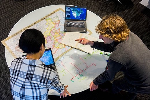
IBM researchers using PAIRS Geoscope service
From vines to data tables
PAIRS Geoscope originated from a joint project between IBM Research and Gallo Winery. The two companies looked to create a precision irrigation system that uses less water but yields more, higher-quality grapes. The project required massive amounts of data from IoT sensors, satellites and other sources to optimize water use efficiency.
"Initially, we worked on a very small vineyard to prove the concept, but once it became successful, we realized that to do it for larger areas we would have to use a massive amount of data in various forms -- image data, vector data [and] sensor data," Hamann said.
IBM examined the technology required to scale the project to support very large data sets, which led to the creation of PAIRS Geoscope.
The PAIRS codename goes back 10 years, but today it's thought of as pairing geospatial data with AI, Hamann said.
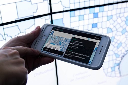
IBM PAIRS Geoscope mobile app
Others playing in geospatial spaces
IBM's not the only cloud provider getting serious about geospatial data services. Earlier this month, Microsoft and GIS mapping software provider Esri joined forces to provide Esri's GeoAI Data Science Virtual Machine (DSVM) as part of Microsoft's Data Science Virtual Machine/Deep Learning Virtual Machine family of products on the Azure cloud platform. The DSVM simplifies the development of AI-based geospatial applications on Azure.
Data scientists and researchers at Microsoft and Esri have used the GeoAI DSVM to automate analysis of land cover maps in fragile watershed environments using deep learning, said Joseph Sirosh, corporate vice president of artificial intelligence and research at Microsoft.